MGRS Tools iPhone app
 Here is a tool designed to help out with four of the more time-consuming tasks associated with military land navigation. The app is free to download from the iOS App Store, supporting GPS location and Distance-Azimuth calculations. If you like what you see, then use In-App Purchase to enable the other three modules Grid4Target, Intersection and Resection.
Unlike most other navigation tools for the iPhone, MGRS Tools is designed to be fully functional without a data connection. This makes the application more useful to our service members when operating in remote training areas or deployed overseas in combat operations.
Technical Aspects
- All MGRS locations use the WGS84 map datum.
- Distance-Azimuth calculations – FROM and TO locations must be greater than 500 meters apart.
- Intersection/Resection – Azimuths from the Observers locations when using Intersection (or back azimuths from Known Points when using Resection) are validated to insure that they intersect prior to calculating a solution.
- As a safety measure, any previously calculated solution is automatically cleared whenever a value is modified in the respective module. Any change in G-M Angle will automatically clear all previously calculated solutions.
Distance-Azimuth
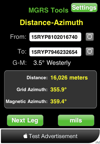 The Distance-Azimuth tool supports GPS location services (the small gray controls to the right of the From and To boxes). Enter two MGRS locations and click on Calculate. The solution provide the distance in meters, and the grid azimuth and magnetic azimuth for navigating to the "To" grid. If you need a more accurate azimuth, press "mils".
Going on a multi-leg journey? (i.e. A to B, then B to C) Save some time by clicking on "Next Leg". The grid in the "To" box automatically is copied into the "From" box, and you just enter your next destination.
Additional Features with In-App Purchase
Grid4Target - Enter your location, and a distance and azimuth to your target. Solution will be the MGRS location of your target.
Intersection - Enter the locations of two observers, and their corresponding azimuths to an observed target or event. The solution will be the MGRS location of the observed target or event. Azimuths are validated to make sure they intersect before a solution attempt is made.
Resection - Enter the MGRS locations of two known points, and the magnetic azimuths to the known points. The solution is the MGRS location of the observer.
Orientation locking - Great for use when on patrols. Place the iPhone or iPod in an exercise band and wear it on your forearm to enable quick MGRS calculations while on the move.
Read a more details at the following URL:
http://militarypro.com/apps/MGRS-Tools
Latest discussions
-
31 Jan 2012 - 21:32 by matac3
 0 comment(s)
 -
30 Jan 2012 - 14:43 by denise
 0 comment(s)
- 1 of 6
- ››
Latest discussion comments
-
by denise
-
by denise